Amber warnings issued as Storm Claudia brings heavy rain and flooding to UK
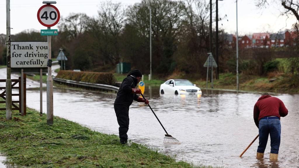 Image source, AFP via Getty Images
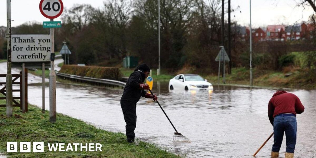
Flooding in Hathern, Leicestershire from January 2025. Flooded roads are again possible on Friday as Storm Claudia brings heavy and persistent rain.
-
Published13 November 2025
Amber warnings have been issued by the Met Office as Storm Claudia brings heavy rain to parts of the United Kingdom.
With rain persisting for much of Friday and into Saturday morning, some areas may get near to their whole month’s worth of rain.
Flooding and difficult travelling conditions are likely with a strong easterly wind also developing.
The warnings come after recent rain and flooding has already affected many areas such as south Wales last week.
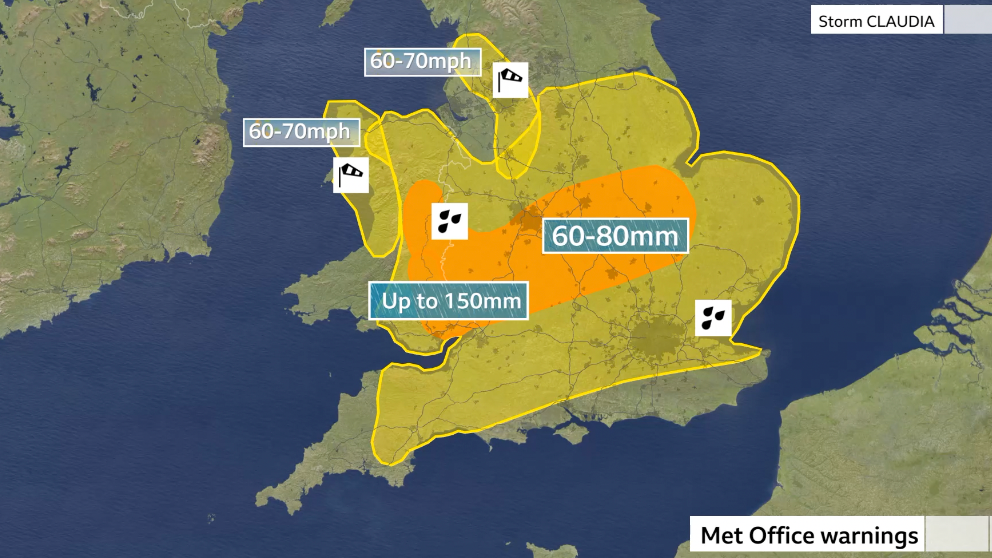 Image source, BBC Weather
Both yellow and amber warnings have been issued ahead of Storm Claudia bringing heavy rain on Friday
Storm Claudia – named by the Spanish Meteorological Agency (AEMET) – has already brought heavy rain and strong winds to Spain and Portugal.
But rain associated with this storm has spread across England and Wales where it has stalled and continues for most of the day on Friday.
A large Met Office yellow severe weather warning is in force across most of England and Wales and will be valid until Saturday at 06:00 GMT.
Around 30-50mm (1.2-2.9in) of rain is expected quite widely which may bring some localised flooding and transport disruption.
But, more severe Met Office Amber warnings, issued for parts of south-east Wales will be in force from 12:00 to 23:59 GMT where up to 150mm of rain – nearly 6 inches – is possible over high ground.
An additional amber warning will also come in to effect for the same time across parts of east Wales, the Midlands and towards eastern England.
Here around 40-60mm (1.6-3in) of rain is likely, with some places seeing up to 80mm (3.2in).
-
How to stay safe during a storm and what to do in a power cut
-
Published20 hours ago
-
The average rainfall for the whole of November across central England and south Wales is between 60-100mm (3-4in), so there is a good possibility some places will see close to their whole month’s rain in 24 hours.
Flooding is likely, especially within the Amber warning areas.
With flood warnings in place in some parts of the country already, Ben Lukey, Flood Duty Manager at the Environment Agency, said:
“Storm Claudia will bring heavy prolonged rainfall across parts of England, with significant surface water flooding probable across parts of central England on Friday, while significant river flooding impacts are also possible, and into Saturday.”
There will also be some difficult driving conditions with transport disruption.
Rail passengers have been warned to check before they travel over the threat of flooding on the tracks and strong winds damaging trees and overhead powerlines. Speed restrictions could also be imposed.
Avanti West Coast said it is running a reduced timetable with fewer trains and journeys taking longer.
CrossCountry Train told passengers it will run a reduced service between Birmingham and Manchester after 13:00 and it some services may be cancelled.
RAC breakdown spokesperson Alice Simpson said: “We urge drivers to take the amber weather warnings associated with Storm Claudia extremely seriously, as they indicate roads are likely to become flooded and therefore represent a risk to life.”
“Drivers may wish to consider delaying their journeys until the worst of the impacts are over, especially in areas that are hardest hit this weekend”.
National Highways said it was checking culverts, gullies and drains to help drain rainwater on the motorway.
Strong easterly winds will accompany the rain.
Additional yellow warnings for the wind have been issued for the far north-west of Wales and the Pennines.
Gusts up to 50-70mph (80-113km/h) could bring some minor damage and disruption.
Some events across the country have been cancelled in anticipation of the bad weather.
In Birmingham, the Jewellery Quarter Christmas Light Switch On was cancelled “due to health and safety concerns” following the Amber warning.
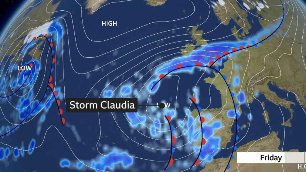
Storm Claudia was named by the Spanish Meteorological Agency and will stay to the south-west of the UK while rain associated with the storm heads into the UK
Why does this storm have a name?
While a typical named storm in the UK might sweep in from the North Atlantic bringing damaging winds.
However, Storm Claudia is notable as a rainstorm rather than a windstorm.
Named by AEMET earlier this week for the impacts it has brought to Spain, the storm is moving up the western side of Portugal and France and approaching the UK from the south-west.
And while it will turn quite windy with gusts up to 70mph (113km/h) in north-west Wales and the Pennines, the winds are not as significant as the rain.
Once one meteorological agency takes the decision to name a storm, there is agreement that all nations use the same name to allow consistency and clearer communication of the impacts.
Claudia does not replace any of the names in the UK’s list of named storms. So we can still expect the next named weather event christened by either the Met office, Met Eirean in Ireland or KNMI in the Netherlands to be Bram.
Very wet start to November
Rain has featured a lot so far this November with some areas seeing over their November average in the first thirteen days.
Shap and Carlisle in Cumbria for example have recorded more than their November rainfall already; 226mm and 95mm compared to the averages of 205mm and 85mm respectively.
Other sites on higher ground such as Honister in the Lake District has recorded over 500mm of rain.
Bannau Brycheiniog – known as the Brecon Beacons – in south Wales, has also been particularly wet with many Natural Resources Wales rainfall stations recording over 200mm of rain so far.
The heavy rainfall in south Wales has also led to some significant flooding in previous weeks.
A business owner who had to close his shop in Carmarthen due to the floods described it as “the worst in living memory”.
Get in touch
How have you been affected by Storm Claudia? Get in touch.

Click here to play ‘Cooler than me?’